Courage, technology and (spatial) data is needed for a bright rural future in Finland
10.11.2023
The war on bugs
15.12.2023AI Solutions for Your Business
During the peak of the Artificial Intelligence (AI) boom, many companies are pondering how to leverage the power of artificial intelligence in their products or services. However, creating a new machine learning model or optimization algorithm from scratch can be quite challenging, even for those who have completed basic AI courses.
But fear not, relief is on the horizon. We, at the Location Innovation Hub, have collected multiple location-based AI methods developed by top researchers and our partner companies. Alongside the AI models, we provide supportive training data, research publications, and other documentation.
Currently, our package includes, for example:
- Deep learning methods that identify changes in aerial images and laser scanning data, allowing you to detect new or demolished buildings. Training data includes information on buildings, roads, and hydrographic features.
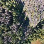
- A deep neural network to identify damage caused by the bark beetle in forests, trained on high-resolution drone images (RGB, hyper- and multispectral).
- Deep learning method to detect anomalies and continuity in GNSS signals, trained on GNSS data from the FinnPos stations and CODE data from the European Space Agency (ESA).
- AI predicting the quantity and quality of silage harvest using remote sensing data (RGB and hyperspectral images, as well as Canopy Height Models).
- AI that generates land-use maps automatically from satellite images and point clouds. Training data includes information on buildings, trees, low vegetation, and water areas.
- A tool for extracting high-quality cloud-free mosaic images from satellite images.
- Toolkit for assessing and mapping mineral occurrences, as well as evaluating their potential.
- A tool that enables AI-assisted identification and extraction of individual zoning regulations from PDF-format zoning documents, and intelligently converts the contents of the documents into searchable formats.
- Method for identifying unknown buildings (and structures) in municipal registers and national registries, and classifying them based on various parameters. The method can utilize national databases as well as satellite or aerial images as its input data.
- Method for multi-criteria optimizing land use implementation. The solution selects the most optimal implementation within the constraints of existing limitations (e.g., population development, budget) concerning objectives (e.g., location, quality, size), and automatically generated scenarios of various possible optimal implementation methods and sequences. Can be used for planning of land policies, property development, and infrastructure timing implementation.
Could any of the above AI methods benefit your organization? Why not contact us and ask more? Most solutions are entirely open and free to our customers.
In addition, we allow you to test AI methods on CSC's supercomputers and you have an opportunity to borrow our top researchers for up to a few days.
This is a great opportunity to kickstart your own AI processes.


