

Data Economy Spotlight 2026 – Apply now
28.01.2026
New in Location Finland: Expanded coverage of 3D building data
The Location Finland test environment is expanding, opening up new opportunities particularly for analysis of the built environment and service development. New 3D building data from the National Land Survey of Finland has been added to the platform, covering several new areas including Kilpisjärvi, Joensuu, and Lappajärvi.
Currently, 3D building data is available for around 45 areas across Finland, and coverage continues to grow. In addition, 2D building data covers the entire country.
One platform, multiple possibilities
Location Finland is a test platform that brings together a wide range of national datasets, all accessible through a single platform. This enables seamless data integration to support the development of location-based services.
“One key use case is assessing solar energy potential. By combining 3D building models with terrain, weather, and climate data, it is possible to analyse, for example, where solar panels should be placed on a roof and how much energy they can generate,” explains Panu Muhli from the Finnish Geospatial Research Institute FGI.

Coverage of 3D buildings in the Location Finland service.
This kind of data supports decision-making in municipalities, energy companies, planning offices, and among property owners. At the same time, it contributes to broader smart city development. High-quality geospatial data and analytics can be used in many ways to improve urban sustainability and energy efficiency.
Location Finland, together with its sister service Location Europe, also supports the development of location-based business. Location Europe provides access to similar datasets at a European scale. Through it, 3D building data is available not only from Finland but also from countries such as Norway, Estonia, the Netherlands, France, and Spain. This enables services to be developed and tested directly with European markets in mind.
“Our Location services provide a standardised, easy-to-use and interoperable way to access data from multiple sources through a unified API structure. This makes combining, analysing, and automating data workflows significantly smoother. For example, 3D buildings, elevation data, and weather data can all be accessed in a consistent way,” Muhli adds.
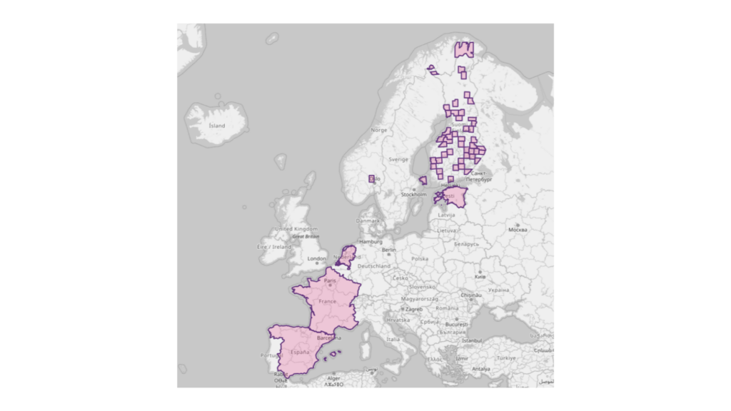
Coverage of 3D building data in the Location Europe service.
Getting started
Data can be explored directly in the browser via the service user interface. For actual use, datasets are accessed through the OGC API by forming queries where the desired data can be selected and filtered. An API key required for access can be obtained free of charge from the Location Finland website.
- Explore Location Finland: locationfinland.fi
- Get a free API key
- Explore Location Europe: locationeurope.eu
- Want to explore how the platform can work for your projects? Location Innovation Hub offers free consultation and can assist with funding applications. Reach out and let's discuss your ideas
For more information
- Panu Muhli, work package lead for Location Innovation Hub’s test services, Location Innovation Hub, firstname.lastname@nls.fi
- Eino Yrjänäinen, GIS specialist, Location Innovation Hub, firstname.lastname@nls.fi


